

17 days
June to September
Islamabad
Gilgit-Baltistan
Open
4114m
Gilgit-Baltistan is a territory of Pakistan, which was formerly known as the Northern Areas. It is the northern most political entity within the Pakistani-controlled part of the former princely state of Jammu and Kashmir.It borders Pakistan’s Khyber-Pakhtunkhwa province to the west, Afghanistan’s Wakhan Corridor to the north, China to the northeast, the Pakistani-administered state of Azad Jammu & Kashmir (AJK) to the south, and the Indian-administered state of Jammu and Kashmir to the southeast. The territory became a single administrative unit in 1970 under the name “Northern Areas” and was formed by the amalgamation of the Gilgit Agency, the Baltistan District of the Ladakh Wazarat, and the states of Hunza and Nagar.
With its administrative center at the town of Gilgit, Gilgit-Baltistan covers an area of 72,971 km(28,174 m) and has an estimated population approaching 1,000,000. Pakistan considers the territory separate from Kashmir, whereas India considers the territory as a part of the larger disputed territory of Kashmir that has been in dispute between India and Pakistan since 1947.
There are more than 20,000 pieces of rock art and petroglyphs all along the Karakoram Highway in Gilgit-Baltistan, concentrated at ten major sites between Hunza and Shatial. The carvings were left by various invaders, traders, and pilgrims who passed along the trade route, as well as by locals. The earliest date back to between 5000 and 1000 BCE, showing single animals, triangular men and hunting scenes in which the animals are larger than the hunters. These carvings were pecked into the rock with stone tools and are covered with a thick patina that proves their age. The archaeologist Karl Jettmar has pieced together the history of the area from various inscriptions and recorded his findings in Rock Carvings and Inscriptions in the Northern Areas of Pakistan and the later released Between Gandhara and the Silk Roads – Rock Carvings along the Karakoram Highway.
Arrive at Islamabad International Airport. Transfer to hotel, relax or explore the capital city with your camera.
Begin your journey north through dramatic landscapes; overnight stay in Chilas.
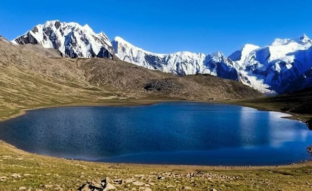
Drive along the Ghizer Valley to reach the tranquil Phander Lake — a paradise for landscape photography.
Spend the day capturing the stunning alpine lake, reflections, local life, and golden hour shots.
Drive to the iconic Hunza Valley with photo stops en route; evening views of Ultar and Lady Finger peaks.
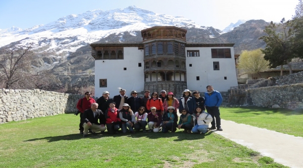
Visit Baltit & Altit Forts, local bazaars, and viewpoints for perfect shots of Rakaposhi and surrounding peaks.
Cross the Hunza River to reach Nagar Valley and Hoper Glacier — ideal for capturing dramatic glacier landscapes.
Full-day trip to the Chinese border at Khunjerab Pass (4733m); return to Passu village for night photography.
Short transfer to Gulmit; explore this cultural village and photograph traditional houses, peaks, and valleys.
A scenic hike along the Ghulkin Glacier to the peaceful Borith Lake; ideal for wide-angle and aerial photography.
A long and scenic drive through mountain roads and valleys to reach Skardu — the gateway to Karakoram giants.
Visit Satpara Lake, Shigar Fort, and local bazaars for a mix of culture and landscape photography.
Recharge and review your photo collection, or do a short walk around the Skardu riverside.
Drive to the beautiful Khaplu Valley, capturing the Khaplu Fort, Chaqchan Mosque, and scenic surroundings.
Begin your return journey south with an overnight stop at Besham via the Karakoram Highway.
Complete the drive to Islamabad; enjoy a final evening of city exploration or photo review.
Transfer to the airport for your return flight with a memory card full of majestic northern Pakistan.
Adventure Land is a Registered Tour operating holding Government License ID-961 company in Pakistan which organize and Operates Expeditions, Treks, Tours, Mountaineering, Safaris and all overland Trips.

Reviews
There are no reviews yet.